
 4/30/15 - After settling up our bill with Charleston Harbor Marina (mile 464.5) we prepared to be on our way. We usually manage our own lines but have always had offers from the host marina for assistance. We had no offer this time and it didn't occur to me that this might be the one time we really would need it. The change in tide here can be as much as 6.5' and because of this they use floating docks exclusively. Backing out of the slip was when I realized how strong the outgoing tide was. As soon as the stern came around the rushing water caught us and forced us back down towards the dock and other boats. We narrowly missed contact with a power boat but did get pulled sideways into the open slip beside it. Under full throttle we pulled ourselves back out into the fairway between the docks but managed to drag the port side against the rubber bumper surrounding the finger pier. We later discovered a 2" wide black racing stripe down most of the length of the boat. I don't have a lot of experience operating a boat in these ripping currents but I suspect the only way to deal with it is to time your arrival and departure during slack tide. It would have been helpful if the staff in the marina office had mentioned this. Driving down the fairway we were starboard side on to the outgoing current and it continued to push us sideways toward the pier. It was a battle getting out into open water and the sense of relief was strongly felt once we were away from this marina. All my experience has been on the Chesapeake Bay with 2' tidal changes. Coming down the ICW we experienced strong tidal flow at anchor but this marina is located on the side of the Cooper River and has no protection from the current. I may be an old dog but hopefully I'm still learning new tricks. I won't put us in that kind of situation again. Woof.
 We motored out across the river and rounded Battery Point into the Ashley River. We saw numerous dolphins along the way. Entering Wappoo Creek we continued south on the ICW. At the head of the creek is a short and narrow cut connecting to the Stono River. The outgoing tide was so strong through here that we could only make 3 knots under full power. We continued on down several connecting waterways over the rest of the day before finally reaching Fenwick Cut off the Edisto River. This connected us to the Ashepoo River where we pulled off the ICW and anchored behind Fenwick Island (mile 511.6) in 18' of water. This area is salt marsh to the south but Fenwick Island is covered with trees providing good protection from any wind from the NW to NE as it was that day. This is an unpopulated area and the only lights we saw at night were from the channel markers upstream on the ICW. We felt totally secluded and were caught off guard the next morning to be passed by a large cruise ship, apparently returning from an offshore gambling run.
5/1/15 - We departed our anchorage at 0900 and proceeded into the Ashepoo Coosaw cut which brought us out to the Coosaw River. Here we had a long upstream run with a headwind of 20 to 25 knots and made slow progress at 4.5 knots. We finally got to Brickyard Creek which wound it's way down to the town of Beaufort, SC. Just upstream from the swing bridge is Factory Creek and we turned up the narrow channel here to get to Lady's Island Marina (mile 535.9), which turned out to be so friendly and accommodating that we ended up staying for four nights.

 We arrived on a Friday afternoon and decided to make use of the marina's loaner car to replenish our groceries. The next day we struck out on foot and crossed the bridge into Beaufort. There was a festival going on in the waterfront park and we spent several hours wandering around the booths and listening to the live music. We walked into town and checked out some shops then headed down Carteret Street in search of a cigar shop, which we finally found out past the college. We each got a cigar and an ice-cold beer and enjoyed them while sitting outside under a large sun umbrella. We continued our walk back through the quiet tree lined streets, eventually finding our way back to the boat in time for dinner. On Sunday we again borrowed the loaner car and drove out to Hunting Island State Park where we spent the day on the beach. Just in from the beach the park is covered in forest with an interesting mix of deciduous trees and palms. There's also a lighthouse here that we viewed from a distance, not feeling up to the challenge of climbing to the top. We walked up and down the beach for several hours before heading back into town. Monday we spent doing laundry and cleaning the boat. It was here that I managed to polish out the racing stripe. This was a quiet day and we spent the afternoon with drinks in the cockpit. We also made use of the car one more time and drove out to Lady's Island for some authentic Low Country eatin' at the Gula Grub.
5/5/15 - We departed Lady's Island Marina around 0930, passed through the swing bridge and continued south under power. We crossed Port Royal Sound and entered Skull Creek behind Hilton Head Island. This brought us out to Calibogue Sound and the Cooper River. Our next anchorage was just off the Cooper River on Bull Creek (mile 565.7). We anchored around the first bend and shared the spot with several other boats. That evening we worked on our 3D puzzle of St. Basil's Cathedral and took in a pretty spectacular sunset


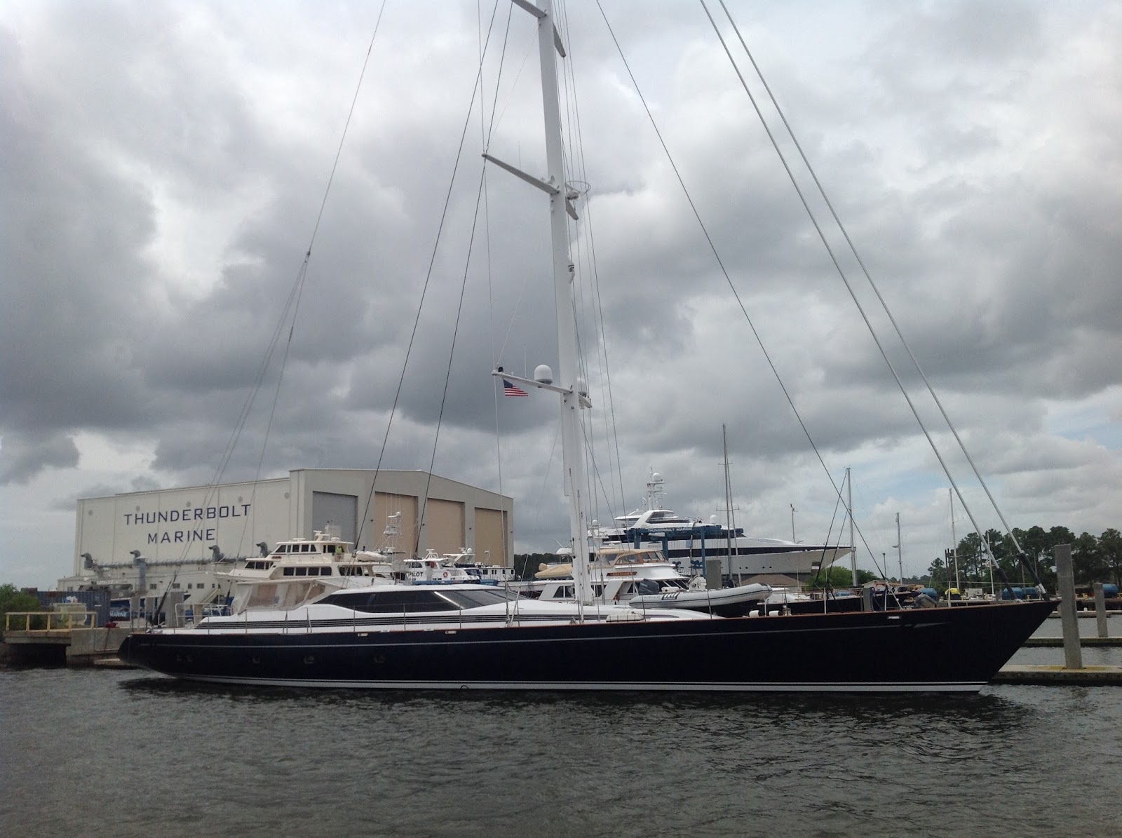 5/6/15 - We continued south through several cuts before crossing the Savannah River and entering into Georgia. We had originally planned to visit Savannah but everything we read said to avoid it because of the 9' tides and strong currents and would be better visited from the nearby town of Thunderbolt. Bummer. I had just finished reading "Midnight in the Garden of Good and Evil" which is a bazaar true story that takes place in Savannah and I was intrigued to see some of the places mentioned. We'll hafta come back by car for a visit some day. We passed through the Elba Cut into the Wilmington River and drifted by a cemetery right on the edge of the river. I instantly recognized it from a picture I had seen and the description as the Bonaventure Cemetery that had played a major role in the "Good and Evil" book. Cool! That kinda made up for not going into Savannah. Just downstream from there we passed the town of Thunderbolt and Thunderbolt Marina. This place caters to megayachts and we saw a number of them on the hard and tied up at the docks including a sloop that must have been at least 80'. If you stay at the marina overnight they'll greet you in the morning with a newspaper and Krispy Kreme donuts. In spite of that temptation we continued to move on.

After passing through four more bridges we came to our next anchorage on Cane Patch Creek (mile 608.4). This entire area is part of a vast salt marsh and has meandering, intersecting creeks. I hafta admit that I totally missed our turn for Cane Patch Creek and we had to backtrack about a mile or so. We had been running with the current making about 8.5 knots and I was just enjoying the feeling of driving a formula one car through the twisty turns of the creek. Or something like that. Anyway, we anchored way back on Cane Patch Creek between tree covered islands. The tall green grass of the salt marsh and the trees provided good protection from the wind and rain that came in that night. The next day we were joined by three other boats and we all waited out an extra day here with reports of tropical storm Ana forming just off the coast. On the morning of 5/7 we saw heavy rain with winds as high as 35 knots but remained safe and secure in our anchorage. During the day the storm worked it's way north up the coast and by the next day we had clear skies again.


2 comments:
Tom, I've tried to comment several times, but have been prevented from actually posting due to some quirk in the blogger comments plug-in. This has happened to me before, and I never know what to expect.
Sounds like your brush with swift current was pretty alarming - not sure what I would have done either. Just don't much experience with it, like you confessed. Must involve judicious use of lines and pivot points. . .
Love your account of the way South - such an adventure!
Rick - I'm not sure what the problem is with posting comments. I checked the settings and they should allow all.
About the current. The real difficulty was backing out straight into the flow and then turning perpendicular to it and shifting to forward gear. The delay in picking up enough forward speed was what got me in trouble. Once we were moving forward down the lane, sideways to the current, the boat was at a 30 or 40 degree angle to the direction we were moving. Not only that, my hair was at right angles to my head the whole time! I think maneuvering in strong current in tight quarters takes experience, a boat with fast response and lotsa power. And good hair gel. None of which I had. I still think the only way to deal with it is to time arrival and departure with slack tide.
Tom
Post a Comment