Sunday, January 3, 2016

Control Freak


We've been landlubbers for something like nine months now.  We've painted the house inside and out, dug up the whole front yard and re-landscaped it.  Got back into stereo gear and other hobbies.  We're looking into getting a grill for the backyard.  Hold on just a dadblamed minute here!  What am I doing?  I'm stuck in the dirt and I've become totally domestic.  And I'm almost enjoying it!  Yikes!  What happened to the boat?

OK, so life does get in the way of our dreams sometimes.  No problem.  Just re-boot and we're back on track.


I got out the parts for my shelved water maker rebuilding project and got back to work on that.  The new membranes are plumbed with high pressure hoses and everything is securely mounted.  The next challenge was to rebuild the control panel.  I was originally going to just clean it up but the low pressure flow meter was the wrong scale for the new feed pump and the new one required more real estate on the panel.  I also found the smaller flow meter for the product water was damaged and needed replacing.  Plus I wanted to add a digital readout for the TDS (total dissolved solids) probe.  Maybe the real kicker was on the back of the panel.  The plumbing components were badly corroded and made of brass.  Brass parts are not rated for high pressure and this in itself convinced me to completely rebuild the control panel.

I carefully removed everything from the panel with plans to clean it up and reuse it.  When I got it stripped bare I found salt water corrosion that had in some places eaten through the aluminum panel.  At this point I decided to build my own panel with all new components and all stainless steel high pressure plumbing.  I don't know why but all my projects seem to snowball.

I went down to the boat and made a detailed drawing of the bulkhead in the aft head, the planned location for the control panel and membranes.  With measurements of every protrusion and obstacle I found that things were going to be kinda tight.  I considered relocating but once I toured the boat with this in mind I realized that I was severely limited and my original choice was the only realistic location.  The two 40" membranes are a limiting factor but the panel itself requires some serious thought.  I want a location that I can get to easily to see the meters and gauges.  Most of the plumbing is connected to the panel and if there's a leak I want to have easy access to repair that too.  The forward bulkhead in the aft head is my best (only) choice.  There's a large mirror mounted in the way so that had to go.  It'd be a shame to lose it though so I'm planning to incorporate the mirror into the control panel enclosure.  Not the highest priority so we'll see how that goes.


My next step was to go on-line and find a company that would make a custom panel for me.  I found one called Front Panel Express (click here).  Located in Seattle, WA they offer a simple free engineering program (CAD/CAM) to work up your design.  Once you have the design finalized you send it to them and within two days your panel is completed and shipped.  Awesome.  I set my design on a grid with 1/8" spacing and went over it a number of times before I had what I wanted.  I laid a towel out on the table and folded it to the size of the panel I wanted.  I laid out all the meters and gauges on the towel to verify I had the spacing correct.  Just as important was the spacing for the plumbing behind the panel.  I went through eight different designs before I had what I wanted.  With that effort completed I sent the design off to be manufactured.  Total cost was about $135 including shipping.  The panel is made of 1/8" black anodized aluminum and everything is NC machined to my design.  I could have had instrument labels machined into the panel which would have upped the wow factor but also would have added unnecessary expense.

Assembling the controls and components went quickly and I'm now waiting on a few plumbing parts from McMaster-Carr to complete it.  The next hurdle will be to build the cabinet to mount the panel and membranes in.

It feels good to be involved in boat projects again.  I can't believe I had wandered so far off course.  It's kinda like Jason and the Argonauts being tempted in to shore by the Sirens.  Just like that.  I was waylaid by the temptations of life on the beach.  That was so close.  I feel much better now.

Wednesday, September 23, 2015

Up A River.....


I've continued to make progress on the water maker.  I've updated the "Project" page where more can be read about this on-going project (click here).

I had previously bought all new gauges and flow meters as well as a nice digital TDS  controller as a start to my home-made RO system.  When I figured out the meters and gauges on my watermaker project needed replacing I decided I was in luck and could just use the new ones I had stored on the boat.  I drove down to get them last Saturday and discovered our boat had been broken into some time in the last two weeks.  Some one had attempted to remove the wind generator, failed and left it dangling over the side.  In the process they broke one of the carbon fiber blades.  Total damage is about $650 in parts.  They also broke the lock and hasp off the companionway hatch and made themselves at home down below.  They went through everything, looking for God knows what because it doesn't appear that they actually took anything.  When we had the boat pulled we removed everything we could so the boat was fairly empty but it still had all the instruments, radios, outboard engine, etc.  Nothing was missing.  When they departed they left the companionway open.  With daily storms blowing through, some of them serious, rain water was blown through the opening and all our teak woodwork down below is now covered with mildew.  All the cabinets in the galley and the entire bulkhead enclosing the aft cabin and aft head need at least a good cleaning.  I reported this to the marina office and they got this stunned look on their faces.  I took a shot in the dark and asked them how many other boats had been broken into.  Ours made fifteen that they knew of.  They asked me if I wanted to file a police report and I said no thinking that the damage was less than my deductable so what's the point.  Cheri and I went back on Monday to clean down below and replace the lock on the companionway.  It was then that we realized the entire interior of the boat is coated with mildew.  Grrr.  What a bummer.  With no power or running water in the long term storage area this becomes a very big job for two people.  I think we may have to  have the boat moved to a different area that has power and water and bring in a cleaning crew.  We went ahead and filed a police report and are in the process of dealing with our insurance company.

Looking around at the other boats around us I'm pretty sure there are more than just fifteen that have been broken into.  There's another Island Packet next to us and looking into his cockpit from ours I can't see a lock on his splash boards.  I also found some rope and a pile of stripped out bolts next to another boat.  Not a good sign.  While we were there another boat owner came by and I mentioned that he should take a close look at his boat.  His lock was also broken off and some things were missing from down below.  When I was getting ready to leave he was standing at the gate to the long term storage area.  He was going to close it for me after I drove through but he didn't have a key.  I asked him how he got in and he said he just squeezed through the gap in the gate.  Gee, that's not so good.  I mentioned all this to the marina office manager.  She mentioned that they were investing in motion sensor cameras for the storage areas.  Great!  How 'bout a security crew too?  This marina has hundreds of boats scattered around several remote lots.  They have zero security other than a chain link fence with some barbed wire at the top.  When they set our boat in there they put the stern within two feet of the fence.  Someone with a little initiative could back a pickup truck up to the fence, throw a blanket over the barbed wire and walk right onto our boat (they're supposed to move the boat further back today).  Of course with the gap in the gate if they're skinny enough they could just walk right in.  The marina used to keep an extension ladder in the area for folks to get on their boats.  That's probably not such a good idea either.  With millions of dollars in boats and gear being stored at this marina they just don't seem to get it.  Security should be a high priority, not an afterthought.

So here we are at Green Cove Springs Marina.  There aren't very many places to keep a larger boat on the St. Johns River which is really too bad.  It's a beautiful river, naturally protected from big storms and just a few days run from the Bahamas.  If I wasn't so anxious to sail away I'd consider opening up a real marina here and give these guys some competition.  Anybody out there looking for a good business opportunity?

Sunday, September 13, 2015

Going With The Flow


So, here we are in Jacksonville, Florida waiting out the hurricane season.  We bought a small house on the west side of town and have been adjusting to being stuck in the dirt again after six years of living aboard.  I like gardening and putzing around the house so it's not all bad.  Plus we have a big garage so I have plenty of space for a shop to work on all those unfinished boat projects.

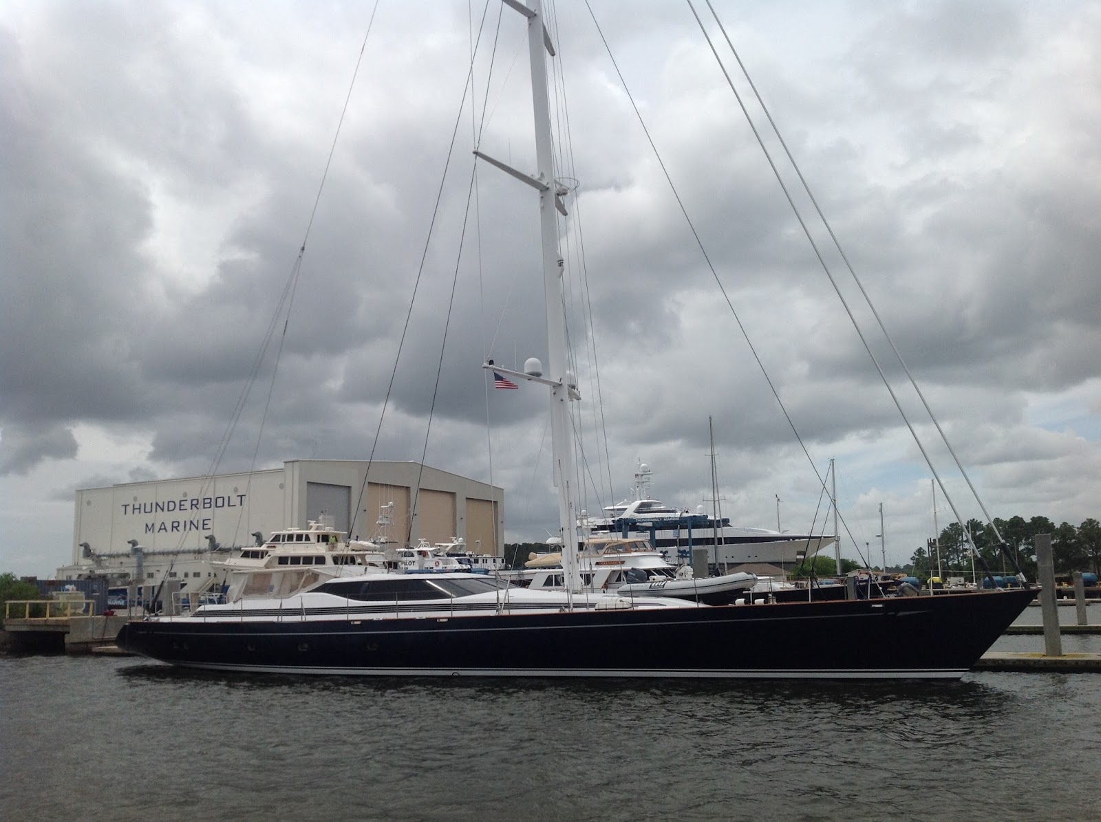
La Vida Dulce is in long term storage on the hard at Green Cove Springs Marina.  When we arrived back in the middle of May we found this place to be more of a third world boat yard than a marina.  They use old concrete Navy piers that were abandoned years ago.  The place had been used for the moth ball fleet because it's located way back on the St. Johns River, very well protected, and has a history of very little impact from tropical storms and hurricanes.  This is the main attraction for us bringing our boat here.  Plus it's only 45 minutes from our new home.


The downside is that the pier is in terrible condition and has been condemned by the local government.  The wooden pilings along the sides are all rotted through and the deck of the pier is way above the level of most pleasure boats requiring a climb up.  There is no power or water either.  When we came in the wind was blowing about 15 knots from the SE, across the pier, making it a challenge to tie up.  Where most marinas have someone come out to the dock and lend a hand, here we had to ask for assistance since this is a "do-it-yourself" marina and everyone is expected to fend for themselves.  We managed to get tied up but the pilings were completely rotted through at water level and we were concerned about the boat getting pulled under the dock if the wind shifted around to the north.  We did manage to move the boat to a position that had a few good pilings so we left the boat over night with some peace of mind.

The next day she was scheduled to be hauled so we got down there bright and early to unload.  Since she was going to be on the hard for months to come we decided to unload everything and rented a U-Haul truck to bring it all home.  When we got the truck there we found that we couldn't drive it out on the pier (although the pier was plenty big enough) and would have to cart everything out to the parking lot.  Between handing everything off the boat up to the dock 6' above deck, bucket-brigade style, and then hauling it down the pier to the truck we didn't get finished until noon.

To get the boat hauled it was then decided that we'd have to loosen the backstays to make room for the hoist.  This also required laying down the wind generator and removing the SSB antenna connection.  With all that done the boat was finally hauled and placed in the long term storage area behind the marina.  This is a large lot with high chain link fencing surrounding it.  There is no power or water available so being able to work on the boat while in storage is pretty limited.  Bummer.


Our insurance company requires the boat to be strapped down to anchors driven deep into the ground as a precaution against storm surge.  When we told the owner of the marina this he laughed and said they hadn't had problems with storms in 35 years.  He asked if we were Canadian since apparently only Canadian insurance companies require the storm straps.  Uhm, no.  Not Canadian.  We were finally told the straps would be put on by the end of the month.  OK, great.  Just in time for the official start of hurricane season.  About a week into June, three weeks later, I went down to check things out.  No straps on our boat but a number of boats pulled after ours had been strapped down.  When I asked about this at the office I was told the marina had decided to strap all boats down and ours would be done within the next two weeks.  I checked back in two weeks and still nothing, was told another two weeks.  My insurance company is calling me twice a week asking for pictures of the boat to prove it's been strapped down.  I keep calling the marina and keep getting told two more weeks.  This went on for three months.  In August I got fed up and got very vocal with the poor gal running the office.  She handed me off to the owner who feigned surprise about my situation, giving me his "word" that the boat would be strapped down within two weeks.  Uhm, gee, I've heard that before.  To my complete surprise they finally came through.

During the past three months of frustration I had searched the internet to see if others had had problems with this marina and found a number of others who had similar experiences.  The folks who work there are all very nice but the place is very poorly run as a business.  Everything is very laid back and run down.  They offer the lowest prices for boat storage and I guess that's the big attraction because they have hundreds of boats on the hard.  But the few hundred dollars saved are lost in the frustration of dealing with these people.  The marina bills itself as a "do-it-yourself" yard which is just fine and would be very attractive to me, being a "do-it-yourself" kinda guy.  Where they fall down is in not doing what they say they're gonna do.  For me, a man's word is his bond.  Nuff said.

So,  we've been using our time ashore to get the house settled in.  We had no furniture or anything so we were really starting over.  That's been kinda fun.  Also did a lot of yard work since the house we bought was an eyesore from the street (two weeks ago we got "yard of the month"!).  We've also used the time to get some medical issues taken care of.  My right arm required several surgeries, all completed now, so I should be back to 100% in time for sailing this winter.

So now I'm using my time to get some of those projects finished up.  I didn't get my shop built in the garage before I had the surgery on my arm so now I'm working one-handed in the dining room.  Maybe mounting the bench vise on the dining room table wasn't such a great idea but I'm out of the heat and am now making some progress.

I started in on the watermaker.  This has been shelved for over a year now and we'll definitely need it when we go to the Bahamas this winter.  This project started out as a complete do-it-yourself system and I had it all planned out for parts and configuration.  Then someone donated an old Sea Recovery system with everything I needed including filters, pumps, hoses and tubing and the controller.  The system is 11 years old so parts of it need to be replaced but everything was in working condition when I got it.  The dealer in Annapolis came through with an owners/installation manual and a rebuild kit for the high pressure pump.  The membranes and housings were in bad shape so I tossed them after stripping off all the fittings and hardware.  Replacing these was the biggest expense for me now.  I decided to increase the fresh water output from 23 to 40 gph by using two 2.5" x 40" membranes (FilmTec SW30-2540, $170 each) and housings (HCTI PV-2540-SW, $395 each).  Most of the fittings on the old membranes were brass and I wanted to use stainless steel so I had to replace those too along with a new high pressure hose to join the two membranes in series.  I got all these parts from Discount Hydraulic Hose (click here) and McMaster Carr (click here).  The stainless fittings are pricey but I got everything I needed for about $200.  The high pressure hoses I got with the system are all in very good condition and have stainless swivel connecters.  All the low pressure tubing and plastic fittings for the product water are also in very good condition.  The braided 3/4" hose for the feedwater is looking kinda sad so I'll replace that but reuse the fittings and clamps.  There are several relays that I'll reuse if they still work but I'll probably back them up with replacements just in case.  The system also included several nice two and three-way valves that I'll clean up and reuse.


I've had the new membranes and housings since last February.  These don't come with any assembly instructions so I spent some time on the net.  Found this paper from FilmTec (click here) which was a help.  The end pieces for the membranes are anodized aluminum with three "O" rings at each end, two on the outside surface and one where the membrane nipple gets inserted.  The end that goes toward the high pressure pump also has a brine seal on the membrane.  The "O" rings need to be lubricated with silicone or glycerine or you'll never get them into the housings.  The membranes come packed in a sealed bag with hydrogenated water or some such thing to keep them moist and well preserved.  Rinse out the housing to clear any dust and particulate matter.  Mount one end piece on the intake side of the membrane and slide it into the housing from either end.  The end piece has to be tapped into place with a rubber mallet so only the flange extends past the end of the housing.  Two anodized aluminum half shells clamp over the end of the housing and hold the membrane firmly in place.  The other end piece is installed in a similar manner.

With the membrane housings put together I'll next assemble the fittings and connector hose.  I'm mounting everything to a short length of 1/2" plywood to hold it all in place as a sub-assembly.  The housings are held in place with some vibration damping clamps modified to work in this setting.  I got these from McMaster Carr (click here) but they're meant to be welded in place so the base needs to be modified so they can be screwed down to the plywood.  To fit the high pressure housings I had to get these sized for 2 3/4" pipe.

After I get the valves and fittings cleaned up I'll concentrate on the control panel.  For now, it feels good to back into this project.  I plan to break it down into sub-assemblies mounted to plywood so when the time comes for installation on the boat it should go fairly smoothly.  Originally I was going to mount everything in the chain locker and under the sole in the forward cabin.  Plan B now has the membranes, filters and control panel mounted in the aft head and the pumps mounted behind the cabinets in the Main Salon.

In addition to the watermaker I have several other projects to wrap up before we depart next winter.  It's going to take about three months to get full use of my arm back so I have some time to play.  Our original plan for circumnavigation is on hold for a while and in the mean time we'll be spending five to six months of the year in the Bahamas.  I guess that doesn't sound so bad.

Going with the flow in Jacksonville, FL.

Tuesday, June 16, 2015

Heading South on the Intracoastal Waterway - Part 7


5/8/15 - We departed Cane Patch Creek anchorage (mile 608.4) at 0930.  This was such a beautiful location it was difficult to leave but we had plans to meet a friend in Brunswick in a few days and time keeps marching on.  Motoring out through the Georgia salt marsh is different from the one we travelled through in South Carolina where we followed a fairly straight 45 mile cut.  Here the ICW is a path of narrow creeks winding it's way through lush green marsh grasses interspersed with low islands of trees.  It's incredibly beautiful.  The Georgia coastline is only about 130 miles long but it's made up of barrier islands with the marshlands forming a seven mile wide corridor between them and the mainland.  The marshlands see tidal changes of six to eight feet and are mostly unpopulated.  The barrier islands have all (except one) been set up as preserves and are for the most part uninhabited.  Cumberland Island is a "national seashore".  Blackbeard Island was once the hangout of the famous pirate and it's rumored that his treasure is buried there.  In 1800 it was acquired by the Navy as a source of live oak timbers for shipbuilding.  In 1924 it became a preserve and in 1940 was made a National Wildlife Refuge.  Jekyll Island was once a winter get away for the ultra-rich.  In the 1880's the Goulds, Rockefellers, Astors, Goodyears, Pulitzers, Morgans and Vanderbelts all built mansions here on huge estates and formed a club of their "social equals".  To encourage social interaction their homes had no kitchens and they were expected to dine together at the clubhouse that was staffed by Delmonico's Restaurant of New York.  This exclusive club held one sixth of the world's wealth and at the start of WWII the government feared for their safety and evacuated the island.  In 1947 the state of Georgia purchased the island for a grand total of $675,000.  It's somehow comforting to know that in this great country everyone gets screwed by the government indiscriminately and proportionately.

As we continued working our way down the ICW we were contacted on VHF radio and told that an Army Corp of Engineers survey boat was approaching us from behind and that we'd need to allow it passage without it's having to change course.  We pulled off to the side and let them by.  The boat was moving at about 10 knots and we watched it disappear around the next bend.  About an hour later he returned and covered the same ground several more times.  It's good to know the Corp is keeping up to date data on the ICW through here.  The Georgia stretch of the ICW has a reputation for poor maintenance with severe shoaling in some places.  We would get a taste of this in a few days.

The rivers flowing through Georgia's lowlands run together between the barrier islands and form large waterways.  These are called "sounds" and we crossed three of them this day; St. Catherines Sound, Sapelo Sound and DoBoy Sound.  While crossing Sapelo Sound we were buzzed by an Air Force C-130 four engine transport plane.  He dropped down low to the water and flew across our bow, then banked hard and flew down our starboard side.  Quite a show and really added some pizzazz to the day.

We anchored that night on the North River (mile 651.3).  We found a quiet spot around the first bend with about 18' of water.  The anchorage was fairly exposed with the only protection being from the tall marsh grasses on either side.  We did have a nice sunset that night and also spent some time working on our 3D puzzle of St. Basil's Cathedral.

5/9/15 - Our destination was Brunswick which is about 30 miles away, probably about five or six hours.  We wanted to time our arrival there so we'd have most of the first day to visit with our friend and we chose our next anchorage so we'd be closer to town.  We departed around 1000 and headed south.  Just 15 miles down the ICW we turned into the Frederica River and wound our way back the narrow channel for five long miles.  We found an excellent anchorage at a bend in the river within sight of old Fort Frederica (mile 665.9) and the state park.  When we first got there we tried anchoring in the wide entrance to the bend and circled around checking the depths.  The entire area was over 40' deep so we continued on past the bend and found a good spot in 25' depth just off the dinghy dock for the park.  This was a beautiful spot with big old live oaks just dripping with Spanish Moss lining the side of the river and within sight of the fort.  We were tempted to blow up our dinghy and go ashore but the heat of the day and the bugs were all the argument we needed to keep us on board.  This area has an interesting history.  Founded in 1736 by James Oglethorpe, a Brit, it was to serve two purposes.  The Spanish had claimed all of Florida and Georgia and this colony was meant as a poke in their eye and was enough to go to battle over.  The town was also a social experiment where England's poor and unemployed could make a fresh start in the "New World".  Wikipedia has a good explanation of the history (click here).

5/10/15 - The Frederica River makes a loop on the ICW and joins it at both ends.  We weighed anchor (lardy dar term) and headed south for another five miles to get to the intersection.  From here we motored across the St. Simons Sound and up the Brunswick River.  We passed under the Sydney Lanier Bridge (suspension type, 185' clearance, picture at top) and turned into the East River.  Our destination was the Brunswick Landing Marina (mile 679.4) at the head of the river.  On our way there we passed a group of fishing boats dressed out with flags and we found out later this was for the "blessing of the fleet", a prayer given for the local fisherman each year by the local Catholic priest on Mother's Day.  Once we got settled in at the marina we called our friend Bobbi and spent the rest of the day at her house.


She offered to take us sight seeing the next day and we spent most of it on St. Simons Island.  We visited the Christ Church, the location where John Wesley (founder of the Methodist church) had preached outdoors under the branches of the live oaks in the 1730's.  The church itself was built in 1880 by Anson Dodge Jr. in memory of his bride who died on their honeymoon.  The small chapel is picture perfect.  Across the street is a park with footpaths winding through the woods and a memorial to John Wesley.  We followed the path out to the other side of the park and found Wesley United Methodist Church.  Built in 1987 with post and beam construction it has walls of concrete embedded with seashells and a humongous pipe organ inside.  Really a beautiful church.  Back to the marina by early afternoon we spent the rest of the day doing laundry and cleaning the boat.  It had been nice to catch up with old friends and we found Brunswick and the surrounding area to be well worth the visit.  We were getting close to the end of our voyage though with plans to be in Green Cove Springs by the middle of May.  It was time once again to move on.

5/12/15 - After topping off our fuel tank we headed back out beneath the Sydney Lanier Suspension bridge and entered Jekyll Creek to continue on the ICW.  We found some serious shoaling as we entered the creek with the posted depth of 15' in actuality being more like 6'.  As we passed a northbound boat we hailed him on the radio to warn of the shoaling he was approaching.  He responded to say that it was nothing compared to what we were headed for.  Several more miles down the creek we entered a one mile stretch of water that was only 5' deep and we literally plowed our way through the mud.  It was a relief to get back into water that was 6' deep or more.  In the chart at left the shallow area we encountered was next to the airport, shown in purple.  Further on we crossed St. Andrews Sound which brought us briefly out to the edge of the Atlantic with breaking waves on the shallows around us.  We entered the Cumberland River and turned off into the Brickhill River (mile 696.2) where we found a secluded anchorage around the first bend tucked in close behind Little Cumberland Island.  Nice peaceful spot with trees on one side and salt marsh on the other.

5/13/15 - We departed Brickhill River around 0930 and turned south on the Cumberland River.  Just a short way down the ICW we came to a spot called Cumberland Dividings where we would turn onto the Crooked River.  As we approached the junction I could see multiple red markers ahead, all in the same spot.  Our chart showed the channel being to the left of center because of a sand bar and there were two red channel markers about 20' apart.  Our chart also showed very shallow water on our port side so I steered for the red marker farthest to the left planning to keep it close to our starboard side.  As we got closer our depth gauge went to zero and we ran hard aground.  I figured the sand bar had extended past the red marker so I tried plowing through to the port side but all that did was turn us sideways and wedge us in harder.  I tried backing down but we were in good.  Or bad.  Since it was low tide all we had to do was wait a few hours and the water level would raise enough to float us off so we shut the engine down and waited.  After about an hour a sailboat approached from the south, went across our bow and turned down our port side into the Cumberland River right along the shore.  Apparently they'd been through this area before.  By my chart they were actually 20' onshore, on dry land, but when I talked to them on the radio they said they had 17' of depth all the way through.  Gee.  Missed it by that much.  I fired up the engine and put it in reverse again and backed down hard, full throttle with the wheel over hard.  We straightened up in the river but just sat there for a few minutes making noise.  Then we inched back a bit.  I swung the wheel over and we inched back a bit more.  Swung the wheel over to starboard and we slowly slid off the sand bar into deep water.  Woohooo!  We backed further up the river until I felt safely distanced from the sand bar and then shifted back to forward gear and turned over to port.  We went in the secret channel right along the shoreline, 17' of water, and followed it out to the Crooked River.  The entire time our chart plotter showed us 20' inland.  Funny.


About 3.5 miles down we came to Cumberland Sound and civilization.  There's a major nuclear submarine base here and beyond that is a very industrialized part of Amelia Island, and our entrance into the state of Florida.  We motored past the town of Fernandina Beach on the Amelia River, crossed Nassau Sound and entered Gunnison Cut behind Talbot Island.  Our final anchorage for this trip was on the Fort George River (mile 735.0) within sight of the Kingsley Plantation.  The history of Fort George and the surrounding area is pretty interesting.  Originally it was the site of a major village of the Timucua tribe and there are massive mounds of discarded oyster and snail shells, fish bones and pottery shards (the mounds are called middens) testifying to their long residence there over hundreds of years.  The Spanish built a mission here in the late 1500's that existed for over one hundred years before being destroyed by the English in 1702.  In 1736 our friend James Oglethorpe (Fort Frederica, Georgia) built Fort St. George here and over the next 90 years the French, Spanish and English wrestled possession of this island from each other.  During the Spanish possession after the end of the American Revolution there were three major plantations owned by Americans here.  One of them, the Kingsley Plantation, left it's mark in history when Florida became a US possession in 1821.  Laws were then established severely restricting the rights of slaves and free blacks and it was at this time that Zephaniah Kingsley lobbied hard for the laws to be changed.  Zephaniah was married to the daughter of an African chief and felt that blacks were the mental equal to whites but that slavery was their destiny.  He worked this twisted logic to his advantage.  He trained thousands of slaves to be skilled labor and sold them for premium prices.  After fifteen years of legal battles he abandoned his plantation, freed his slaves and brought them with his family to Haiti.

5/14/15 -  We were now within one days run to the end of our journey. Ever since we anchored out at Cane Patch Creek on 5/8 I'd had this feeling that we were close to the end and I didn't want it to stop.  We'd had such a great time coming down here, spent more time together than in the last six months and really enjoyed it.  The funny thing is that before we decided to do the ICW I had no interest in it at all.  We had always planned to start our trip, our circumnavigation, by sailing straight to the Bahamas, taking maybe ten days of direct ocean sailing to get there.  I mean, why bother motoring for a month on inland waters? But then life happened and we had to modify our plans.  Buy a house, do the islands on a part-time basis for a while.  We still hope to see the world some day but ya gotta play the cards you're dealt.  Once we realized we wouldn't be able to go to the islands this year we decided it really made sense to make the most of the inland waterway trip.  And now that's coming to an end.  Bummer.  There are upsides to being stuck in the dirt like being able to spend time with my Mom who's been lost in Scotland for the last ten years.  And we both really do enjoy fixing up the house and having space to do our hobbies and blah, blah, blah.  We'll make the most of all that.  It's just that when you're in the midst of something that was unexpectedly good you hate to see it end.  These were my thoughts on the morning of this day.


We departed Fort George anchorage and continued south.  We passed through Sister's Creek bridge (bascule) and shortly after turned up the St. Johns River (mile 739.7).  This officially ended our time on the ICW but we still had eight bridges to contend with before reaching the end of our journey.  The first three were high fixed bridges with plenty of clearance for large ships.  As we got into downtown Jacksonville we ran a gauntlet of four more.  The first was the Main Street bridge (lift) and we called ahead to let the bridge tender know we were on our way.  As we approached, the bridge raised with perfect timing and we passed beneath.  Just on the other side  though we encountered three more tightly grouped together.  The one in the middle was a railroad bridge and as luck would have it we got there just was a train was approaching.  We drifted, backed and circled with several other boats while waiting to get through.  The bridge finally opened and we had an uninterrupted run up the rest of the river, passing under the Buckman Bridge (fixed, 65') several miles further on.  We had a beautiful day and put up the sails for a short while but neither of us were really into it so we motored in the rest of the way.  We arrived at Green Cove Springs Marina around 1530.  End of story.  Actually, this was the end of our voyage but there's more to the story which will continue at another time.

Here's some stats:

  • Distance of voyage - approximately 900 miles including 90 miles at the beginning from Herrington Harbour to Mobjack Bay,  32 miles from there to Hampton Roads and then 12 more down to Hospital Point (mile 0.0 on the ICW).  At the end on the St. Johns River we added another 35 miles too.
  • Bridges - way too many, something like 78 bridges
  • Groundings - hard aground twice and bumped about six or seven times.
  • Fuel consumed - approximately 210 gallons.  71 gallons at Dowry Creek Marina ($2.99/gal), 70 gallons at Charleston Harbor Marina ($3.65/gal), ? gallons at Brunswick Landing Marina.  We haven't topped off the tank since we arrived in Green Cove Springs so I'm guessing 70 gallons more including Brunswick.
  • Stayed in eight marinas for a total of 15 nights.  $$$
  1. Dismal Swamp Welcome Center, 4/9 - 4/10
  2. Dowry Creek Marina, 4/14
  3. River Dunes Marina, 4/15 + 4/16
  4. Cricket Cove Marina, 4/21
  5. Harborwalk Marina in Georgetown, 4/23 + 4/24
  6. Charleston Harbor Marina, 4/27 - 4/29
  7. Lady's Island Marina in Beaufort, 5/1 - 5/4
  8. Brunswick Landing Marina, 5/10 + 5/11
  • Total length of voyage was 40 days, 4/5 to 5/14.  I guess that means we spent 25 nights at anchor.
  • We saw bunches of dolphins and eagles and all kinds of wildlife but not one single alligator.  I really was hoping to see one.
All in all this was a great trip and I'm glad we decided to do it.  I'm not sure I'd ever want to do it again  because I think it would get kinda monotonous after the first time but it was a great experience and I picked up some new skills along the way too (like getting off sand bars and avoiding strong currents).  We saw some old friends along the way and made some new friends too.  This was definitely a nice way to start out our retirement.


Friday, June 12, 2015

Heading South on the Intracoastal Waterway - Part 6


4/30/15 - After settling up our bill with Charleston Harbor Marina (mile 464.5) we prepared to be on our way.  We usually manage our own lines but have always had offers from the host marina for assistance.  We had no offer this time and it didn't occur to me that this might be the one time we really would need it.  The change in tide here can be as much as 6.5' and because of this they use floating docks exclusively.  Backing out of the slip was when I realized how strong the outgoing tide was.  As soon as the stern came around the rushing water caught us and forced us back down towards the dock and other boats. We narrowly missed contact with a power boat but did get pulled sideways into the open slip beside it.  Under full throttle we pulled ourselves back out into the fairway between the docks but managed to drag the port side against the rubber bumper surrounding the finger pier.  We later discovered a 2" wide black racing stripe down most of the length of the boat.  I don't have a lot of experience operating a boat in these ripping currents but I suspect the only way to deal with it is to time your arrival and departure during slack tide.  It would have been helpful if the staff in the marina office had mentioned this.  Driving down the fairway we were starboard side on to the outgoing current and it continued to push us sideways toward the pier.  It was a battle getting out into open water and the sense of relief was strongly felt once we were away from this marina.  All my experience has been on the Chesapeake Bay with 2' tidal changes.  Coming down the ICW we experienced strong tidal flow at anchor but this marina is located on the side of the Cooper River and has no protection from the current.  I may be an old dog but hopefully I'm still learning new tricks.  I won't put us in that kind of situation again.  Woof.


We motored out across the river and rounded Battery Point into the Ashley River.  We saw numerous dolphins along the way.  Entering Wappoo Creek we continued south on the ICW.  At the head of the creek is a short and narrow cut connecting to the Stono River.  The outgoing tide was so strong through here that we could only make 3 knots under full power.  We continued on down several connecting waterways over the rest of the day before finally reaching Fenwick Cut off the Edisto River.  This connected us to the Ashepoo River where we pulled off the ICW and anchored behind Fenwick Island (mile 511.6) in 18' of water.  This area is salt marsh to the south but Fenwick Island is covered with trees providing good protection from any wind from the NW to NE as it was that day.  This is an unpopulated area and the only lights we saw at night were from the channel markers upstream on the ICW.  We felt totally secluded and were caught off guard the next morning to be passed by a large cruise ship, apparently returning from an offshore gambling run.


5/1/15 - We departed our anchorage at 0900 and proceeded into the Ashepoo Coosaw cut which brought us out to the Coosaw River.  Here we had a long upstream run with a headwind of 20 to 25 knots and made slow progress at 4.5 knots.  We finally got to Brickyard Creek which wound it's way down to the town of Beaufort, SC.  Just upstream from the swing bridge is Factory Creek and we turned up the narrow channel here to get to Lady's Island Marina (mile 535.9), which turned out to be so friendly and accommodating that we ended up staying for four nights.

We arrived on a Friday afternoon and decided to make use of the marina's loaner car to replenish our groceries.  The next day we struck out on foot and crossed the bridge into Beaufort.  There was a festival going on in the waterfront park and we spent several hours wandering around the booths and listening to the live music.  We walked into town and checked out some shops then headed down Carteret Street in search of a cigar shop, which we finally found out past the college.  We each got a cigar and an ice-cold beer and enjoyed them while sitting outside under a large sun umbrella.  We continued our walk back through the quiet tree lined streets, eventually finding our way back to the boat in time for dinner.  On Sunday we again borrowed the loaner car and drove out to Hunting Island State Park where we spent the day on the beach.  Just in from the beach the park is covered in forest with an interesting mix of deciduous trees and palms.  There's also a lighthouse here that we viewed from a distance, not feeling up to the challenge of climbing to the top.  We walked up and down the beach for several hours before heading back into town.  Monday we spent doing laundry and cleaning the boat.  It was here that I managed to polish out the racing stripe.  This was a quiet day and we spent the afternoon with drinks in the cockpit.  We also made use of the car one more time and drove out to Lady's Island for some authentic Low Country eatin' at the Gula Grub.


5/5/15 - We departed Lady's Island Marina around 0930, passed through the swing bridge and continued south under power.  We crossed Port Royal Sound and entered Skull Creek behind Hilton Head Island.  This brought us out to Calibogue Sound and the Cooper River.  Our next anchorage was just off the Cooper River on Bull Creek (mile 565.7).  We anchored around the first bend and shared the spot with several other boats.  That evening we worked on our 3D puzzle of St. Basil's Cathedral and took in a pretty spectacular sunset


5/6/15 - We continued south through several cuts before crossing the Savannah River and entering into Georgia.  We had originally planned to visit Savannah but everything we read said to avoid it because of the 9' tides and strong currents and would be better visited from the nearby town of Thunderbolt.  Bummer.  I had just finished reading "Midnight in the Garden of Good and Evil" which is a bazaar true story that takes place in Savannah and I was intrigued to see some of the places mentioned.  We'll hafta come back by car for a visit some day.  We passed through the Elba Cut into the Wilmington River and drifted by a cemetery right on the edge of the river.  I instantly recognized it from a picture I had seen and the description as the Bonaventure Cemetery that had played a major role in the "Good and Evil" book.  Cool!  That kinda made up for not going into Savannah.  Just downstream from there we passed the town of Thunderbolt and Thunderbolt Marina.  This place caters to megayachts and we saw a number of them on the hard and tied up at the docks including a sloop that must have been at least 80'.  If you stay at the marina overnight they'll greet you in the morning with a newspaper and Krispy Kreme donuts.  In spite of that temptation we continued to move on.


After passing through four more bridges we came to our next anchorage on Cane Patch Creek (mile 608.4).  This entire area is part of a vast salt marsh and has meandering, intersecting creeks.  I hafta admit that I totally missed our turn for Cane Patch Creek and we had to backtrack about a mile or so. We had been running with the current making about 8.5 knots and I was just enjoying the feeling of driving a formula one car through the twisty turns of the creek.  Or something like that.  Anyway, we anchored way back on Cane Patch Creek between tree covered islands.  The tall green grass of the salt marsh and the trees provided good protection from the wind and rain that came in that night.  The next day we were joined by three other boats and we all waited out an extra day here with reports of  tropical storm Ana forming just off the coast.  On the morning of 5/7 we saw heavy rain with winds as high as 35 knots but remained safe and secure in our anchorage.  During the day the storm worked it's way north up the coast and by the next day we had clear skies again.

Wednesday, June 10, 2015

Heading South on the Intracoastal Waterway - Part 5


4/25/15 - We departed Georgetown (mile 403.0) with our next destination being Charleston, SC which was over 60 miles away.  This would make for a very long day so we chose an anchorage from the guidebook that would work better for us and still get us close.  Heading south on the Waccamaw River into Winyah Bay we entered the Estherville Minim Creek Canal (4.9 miles).  This empties out into a series of landcuts and canals that wind around for the next 45.5 miles through salt marshes.  Driving a boat through the salt marshes is kinda like driving your car through a town with endless intersecting creeks that form a maze forcing you to pay attention to the roadmap, er, charts.  There's also a strong tidal flow and it's associated shoaling through here and that requires paying close attention to the depth gauge.  After 45 miles we felt exhausted and were ready for the next anchorage.  We pulled off the ICW into Dewees Creek and turned into Long Creek (mile 454.3).  We chose this spot because it offers some protection from the strong winds blowing that day.  We anchored in 18' depth with the wind blowing 25 knots and a strong tidal flow in the opposite direction.  Because of the depth, the 6' tide and the strong wind I let out 120' of chain.  Cheri and I use simple hand signals when anchoring for communication and to minimize yelling and confusion.  To ensure that we got the anchor to set properly I gave her the signal for backing down hard in reverse.  When the anchor bit into the sand, mud and shell bottom it was like it had been set in concrete.  We stopped so quickly the bow of the boat dipped down and I was almost thrown over.  Guess we don't have to worry about dragging anchor tonight!  That evening a storm blew in with rain and lightning which lasted through the next day.  We decided to just sit it out for an extra day.

4/27/14 - Our anchorage on Long Creek was just 10 miles out of Charleston (mile 464.5) and from that distance we could see the Ravenel suspension bridge (first picture at top) and the city lights at night.  We departed Long Creek at 1030 and headed south on the ICW, passing under the Isle of Palms bridge (fixed, 65').  The approach to the second bridge, the Ben Sawyer swing bridge, had severe shoaling with depths as shallow as 5'. We touched bottom several times and there was quite a bit of VHF traffic about how best to get through.  When we arrived at the swing bridge we had to wait half an hour for it's next scheduled opening.

We had tried to make reservations at marinas in the city but they were all full so we ended up across the Cooper River at Charleston Harbor Marina.  We found this place to be very expensive with diesel priced a dollar higher ($3.65/gallon) than anywhere else on the ICW and slip rates at $2.15/ft.  The location also suffered from a strong tidal flow that made entering and departing the slip very difficult.  Grrr.  They did offer a water taxi service ($6.00 in each direction) but redeemed themselves with a free shuttle that only took 15 minutes to get into Market Street in Charleston.  We made good use of the shuttle.

Once we got settled in at the marina we headed over to Charleston and spent the afternoon touring the city.  We started at the Slave Museum where we picked up a book for a self guided tour of the city.  We spent the rest of the day wandering the streets of the old part of town, learning the history and enjoying the beauty.  Had lunch at the Brown Dog Cafe.  On 4/28 we returned for another day of wandering.  Charleston is known for fine dining and has a long list of excellent restaurants.  We stumbled on 82 Queen for lunch and enjoyed our meal while seated outside in the courtyard.  We had no real plans for this day, mostly intentions to shop.  We didn't get far though before we discovered a nice little cigar shop that also offered beer and wine.  We commandeered a table just inside the entrance and stayed there for five hours.  We spent the rest of the day making new friends with the shop owner and several of the locals.  One in particular was an older gal who turned out to be a professional walking-tour guide in the city.  She loved to talk and if you had listened in on the conversation you would have thought we had all known each other for years.  Another character we met was an author who was working on a book about serial murderers in the US.  This was the highlight of our visit to Charleston.  Fine wine, great cigars and friendly and interesting people.  Who could ask for more?

Our last day there was a rainy one so we spent it at the marina doing laundry and cleaning up the living quarters on the boat.  Next to the marina was a Naval Museum with an aircraft carrier (USS Yorktown) and destroyer (USS Laffey).  We wandered over and took a look but didn't want to invest in the $40 (for two) entry fee.


This is a beautiful city with history going back to it's 1670 origins.  In 1718 the city was besieged by Blackbeard the pirate and in it's early years was under constant attack by the French, Spanish and Native Americans.  During the Revolutionary War the city was attacked by the British fleet several times.  The first time they were repelled by a hastily built fort made of Palmetto logs.  The "liberty" flag flown in this battle became the state flag for South Carolina with the addition of a Palmetto tree emblem commemorating this battle.  The second attack in 1780 was more successful and the British held the city for two years.  This was considered the greatest American defeat of the war.

Charleston played a leading role in the slave trade with something like 40% of all slaves in America brought over from Africa.  When international slave trade was outlawed in 1808 Charleston became the center of an even larger domestic slave market with slaves being brought there for sale from all over the south.  The slave museum we visited had been a huge indoor slave market in the mid-1800's.  We learned that our home state of Maryland was a major contributor.  During this time Charleston also became a big exporter of Indigo, a blue dye that was in short supply in Europe.  It's also what's used to make bluejeans blue.  In 1862 the attack on Fort Sumter in Charleston's harbor began the Civil War.  During the war a blockade was established that effectively ended commercial traffic in the city.  It was at this time that one of the first submarines, the H.L. Hunley, was used in naval warfare, attacking one of the ships in the blockade.  In 1861 Charleston was ravaged by fire, unrelated to the war, which burned over 500 acres of the city.  In 1886 the city was nearly destroyed by one of the strongest earthquakes to hit the East Coast, registering 7.3 on the Richter scale, second only to the New Madrid earthquakes of 1811 and 1812.  The city's economy languished for decades but has recovered to become well known world-wide for it's art, music, local cuisine and fashion.  We found Charleston to be a beautiful city with an interesting history and plenty of interesting people.  This was  easily the best part of our trip down the ICW.