click here for EarthNC charts to see where we went
The installation of the wind generator took much longer than I had anticipated and pushed back the start of our vacation from Friday, 5/27 (which was really wishful thinking anyway) to Sunday, 5/29. Then we started thinking about all the crazy boaters out on the Bay over Memorial Day Weekend and decided it'd be smarter to leave on Monday when everyone else would be heading home. By the time we'd get to Cuckold Creek on the Patuxent River we'd have the whole place to ourselves. Good plan.
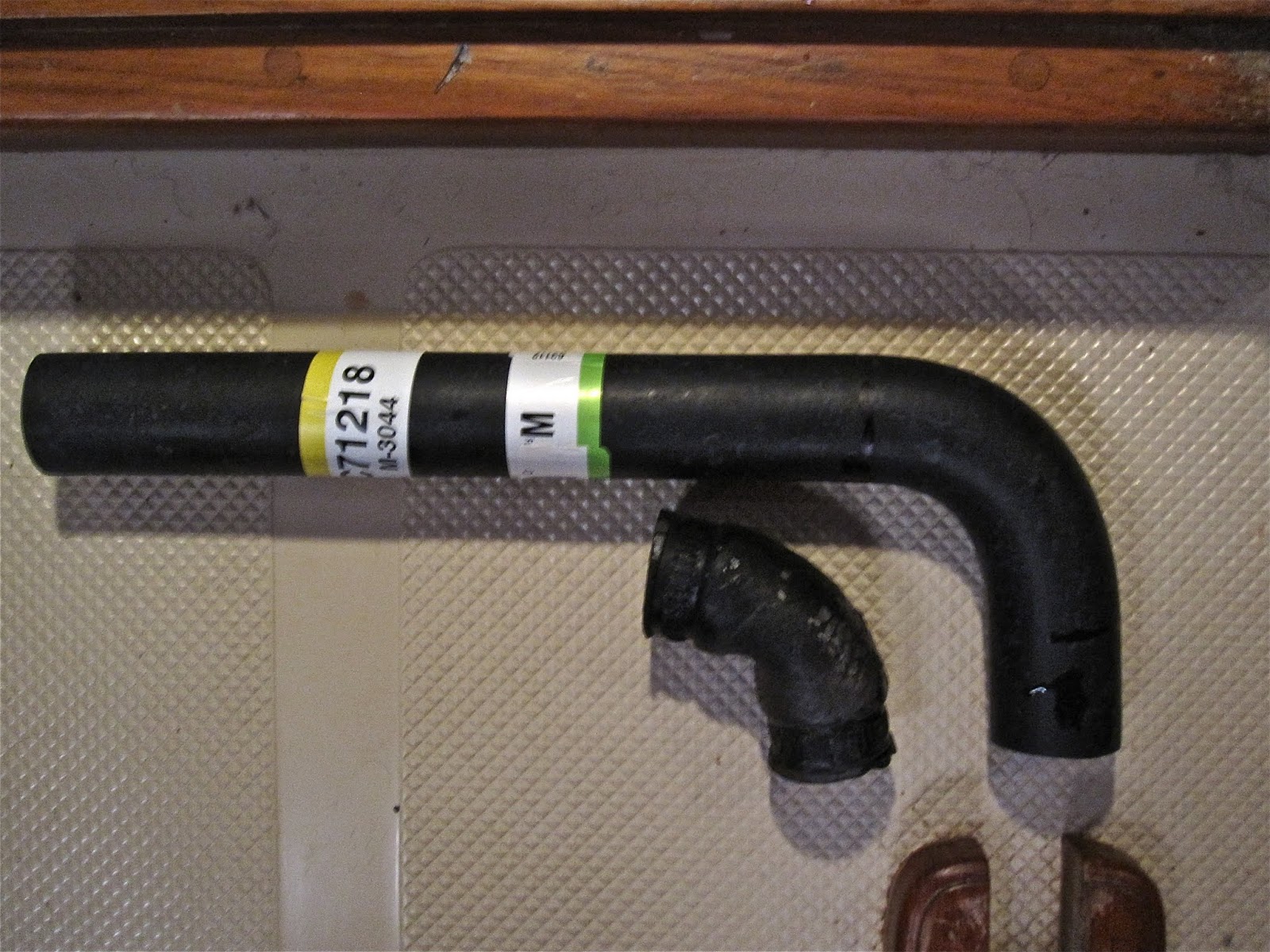
So Monday morning, 0730, we're ready to go. I fire up the engine and go below to do our routine visual check to make sure it's behaving properly. It's not. I notice some coolant in the drip pan and as I look around I notice a fairly rapid drip coming from the hose on the thermostat. When I take a closer look I find the hose is split just past the hose clamp and is leaking down the underside and dripping down to the pan. I'm pretty sure this has been leaking ever since we bought the boat. We've always found fluid in the pan after running the engine but could never find the source of the leak. The only reason I found it this time was because I was looking in from the side at an odd angle and just happened to see the leak at the hose.


Because of the leak rate I felt that we needed to change this baby out before we went anywhere. This was the one hose I didn't change when I replaced the heat exchanger. Figures. I had gotten a replacement for it from Yanmar but the hose they gave me was straight and I needed one with an 80 degree bend. When I tried to put it on it kinked so badly I was concerned about flow restriction so I just put the old one back on. Now I'm paying the price for that decision. So, it's 0730 and the local Yanmar dude doesn't even get in until 0900 on Tuesday, this being a holiday. I know it'll take at least three days to get a hose from the factory and even then it might not be the right one. I decided to wait it out another day and see what he might suggest. My brain works best in subconscious mode and overnight I came up with a better solution. Instead of waiting until 0900 for the Yanmar dude I drove down to the local Auto Zone at 0800 and asked if I could hunt through their pre-formed radiator hoses for one that might work. Found what I needed ($10), took it home and cut out the short bend that I needed to make the repair. It looks like it was made for it. Perfect. Did I mention that the Yanmar hose cost $50?

(
Chart of Hudson Creek) By the time we took care of a few other things it was the middle of the afternoon. I figured this was too late to attempt a trip to the Patuxent but we could still make it over to the Little Choptank and then have a short run over to the Patuxent the next day. It's always good to be flexible. So, on the hottest day so far this year, 96 in the shade, and with zero wind we motored across the Bay and anchored behind Casson Point on Hudson Creek. This is a beautiful spot, secluded, well protected with good depth, 10', and good holding for the anchor. We got there around 1930 and after we were settled in I went for a swim. The water was slightly salty and felt like about 85 degrees, a bathtub. About 45 minutes after the sun went down a nice breeze kicked up that kept us comfortable for the rest of the night. After breakfast and a morning swim we took off and headed out towards the Bay for our next destination.
(
Chart of Cuckold Creek) We motored out the Little Choptank to G3 behind James Island before setting sail, heading up to G1 and then shooting out westward across the Bay. The wind was out of the south at about 15 knots and we tacked our way down to the Patuxent. We then ran under power past Solomons Island and after passing under the Rte 4 bridge turned into Cuckold Creek on the south side of the river. As soon as we got to R4 we turned to port and entered a beautiful secluded little cove on the north side of Mill Creek. There's no houses on this side of the creek and with no other boats we had the place to ourselves. We anchored in 12' of water with good holding and settled in for the night. I had an evening swim to cool off and took a brush to the waterline of the boat and scrubbed off the scumline that had built up over the winter. We had a cool breeze that kept us comfortable throughout the night. In the morning we headed out with a stiff 20 knot breeze out of the north. After we passed under the Rte 4 bridge we ran under sail, main and staysail, for easy one man handling while Cheri was on a conference call. By the time she got off the phone we were out in the Bay sailing wing and wing on a north breeze and had gotten as far south as the Navy target area.

We continued on past Point No Point but as we approached Point Lookout at the mouth of the Potomac River the wind veered around to the west and cranked up to 30 knots. The river is quite wide here, over seven miles across, and as we turned into it we had to tack back and forth against the wind and what we estimated to be 6' waves, not to mention the natural outward flow. "Mr. Toad's wild ride" pretty much sums it up. In fact, after tacking for over two hours and making no progress at all we finally gave in, fired up the engine and secured the sails. Even then, under power at 2500 rpm's we only made 3 knots at best. We eventually made our way over to the northern shore where the waves weren't so bad and made good progress from there up to St. Mary's River. Check out our videos (
click here) and (
then click here).
(
Chart of St. Marys River) St. Mary's River is probably the prettiest river on the Chesapeake Bay. It winds back through wooded hillsides with occasional views of historic mansions. The oldest estate in Maryland, built in 1644, is located here. Once back into the protected shores of the river the wild winds were reduced to pleasant breezes. We worked our way into St. Inigoes Creek and found a good anchorage back in Church Cove with 13' of water and good holding. Despite being surrounded on all sides by large homes, the cove is large enough that we anchored out in the middle and felt totally secluded. There's probably room in this cove for 20 boats but we were fortunate to share it with only one other for the night we were there. I continued with my morning and evening swims here.


The next morning we decided to explore the rest of the river to see if we could find a more secluded anchorage. We powered our way up the river past historic St. Marys City, the first capital of Maryland, and wound our way upriver to Tippity Wichity Island. On the charts this looked like a really nice spot to anchor for the night plus that island just has a really cool name. Once we got up to the area though, we found the banks to be shorn of trees and lined with houses and farmland. The river really widens out at this spot and I felt that as an anchorage it didn't provide the kind of protection I was looking for. We headed back downriver and Cheri went below to bake cookies and cook up some bacon for use in later meals. As we approached Horseshoe Bend I decided we needed to spend some time ashore in the old city for a chance to stretch our legs. We were the only boat within sight and took advantage of that by pulling up to the College dock where we were assisted by a smiling student. We walked into the reconstructed town, wandered through the graveyard reading old headstones and gave Bella a chance to run loose in the large grassy area by the boathouse. We hiked down to Church Point and wandered around the village too. There's a big herb garden behind one of the houses and the nice lady in the gift shop allowed us to fill a bag with fresh cuttings. The big attraction for me was the Dove, a reproduction of one of the ships that brought the first colonists to this area. This thing is only 10' longer than La Vida Dulce. Back at the dock we rinsed the boat off with fresh water, emptied our trash and continued on our way.

(
Chart of Price Cove) St. Marys River offers a number of excellent spots to anchor but we chose to head back out to the mouth of the river to get a quicker start in the morning. We were looking for an anchorage that would be fairly secluded and safe. On the north shore of the river right at the entrance is Saint Georges Creek and just inside that to starboard is Price Cove. The wind was still blowing 25 knots out in the open river and we were really hoping for a nice peaceful spot for the night. Price Cove is tucked back out of the way surrounded by flat grassy areas and occasional stands of tall trees. There isn't much protection from the wind but the water is calm being almost totally enclosed by land and, best of all, there are no houses at all. We anchored way back there by the duck blind and had a good breeze to keep us comfortable and the boat hardly moved at all. Swimming was good here too. This is a really nice anchorage.

The next morning (Saturday, 6/4) we headed out around 0930, early for us. The wind had died down to almost nothing so we ran under power out to the mouth of the Potomac. Here we encountered what's called the Potomac Swim (
click here), where a large group of crazy people swim 7.5 miles across the widest part of the river. When we arrived there were swimmers and kayaks and small boats stretched all the way across the Potomac. I spotted a pretty good gap and headed for it. Cheri stood up in the bow and kept watch for potential targets. I got a call on the radio from the Coast Guard and responded to them but another boat stepped on my response so I don't think they got it. All of a sudden this high speed USCG river boat comes flying up beside us. I throttled back and they pulled up right next to us and I'm thinking "whew, got all that safety stuff just in time". They asked if I knew there were swimmers in the water and I pointed out that we had posted a safety watch for that very reason. They were duly impressed and told us to carry on and enjoy our voyage. Nice fellas.
Once past the line of swimmers we headed out to Smith Point Light. It was here that we passed fairly close to the presidential yacht U.S.S. Sequoia (
click here). This is a 104' motor yacht built in 1925 and is a historic national landmark. She was used exclusively as a presidential yacht until 1977 when Jimmy Carter had her decommissioned, just one of the many unforgettable things he accomplished during his presidency. Hey, let's give away the Panama Canal! But I digress. This beautiful yacht is available for charter in DC for about a gazillion $/hour and I'm wondering what she was doing way out at Smith Point Light. Didn't look like there were any guests aboard but I did see a tall, skinny, black dude at the wheel. I wonder.....
Because of the length of our trip I'm going to divide this up into several parts. It's taken me forever to get this far on it and there's still another week to go. Look for part II coming soon. I swear.


 Because of the leak rate I felt that we needed to change this baby out before we went anywhere. This was the one hose I didn't change when I replaced the heat exchanger. Figures. I had gotten a replacement for it from Yanmar but the hose they gave me was straight and I needed one with an 80 degree bend. When I tried to put it on it kinked so badly I was concerned about flow restriction so I just put the old one back on. Now I'm paying the price for that decision. So, it's 0730 and the local Yanmar dude doesn't even get in until 0900 on Tuesday, this being a holiday. I know it'll take at least three days to get a hose from the factory and even then it might not be the right one. I decided to wait it out another day and see what he might suggest. My brain works best in subconscious mode and overnight I came up with a better solution. Instead of waiting until 0900 for the Yanmar dude I drove down to the local Auto Zone at 0800 and asked if I could hunt through their pre-formed radiator hoses for one that might work. Found what I needed ($10), took it home and cut out the short bend that I needed to make the repair. It looks like it was made for it. Perfect. Did I mention that the Yanmar hose cost $50?


 The next morning we decided to explore the rest of the river to see if we could find a more secluded anchorage. We powered our way up the river past historic St. Marys City, the first capital of Maryland, and wound our way upriver to Tippity Wichity Island. On the charts this looked like a really nice spot to anchor for the night plus that island just has a really cool name. Once we got up to the area though, we found the banks to be shorn of trees and lined with houses and farmland. The river really widens out at this spot and I felt that as an anchorage it didn't provide the kind of protection I was looking for. We headed back downriver and Cheri went below to bake cookies and cook up some bacon for use in later meals. As we approached Horseshoe Bend I decided we needed to spend some time ashore in the old city for a chance to stretch our legs. We were the only boat within sight and took advantage of that by pulling up to the College dock where we were assisted by a smiling student. We walked into the reconstructed town, wandered through the graveyard reading old headstones and gave Bella a chance to run loose in the large grassy area by the boathouse. We hiked down to Church Point and wandered around the village too. There's a big herb garden behind one of the houses and the nice lady in the gift shop allowed us to fill a bag with fresh cuttings. The big attraction for me was the Dove, a reproduction of one of the ships that brought the first colonists to this area. This thing is only 10' longer than La Vida Dulce. Back at the dock we rinsed the boat off with fresh water, emptied our trash and continued on our way.


1 comment:
I am really enjoying being part of this trip with you! The Blog is beautifully written and very interesting in every way!
Post a Comment