
Chart Showing Warehouse Creek
Pictures From Our Warehouse Creek Trip
Thursday, 3-17-11, was forecast to be excellent weather, continuing on through the weekend. We used my recent birthday as an excuse to take a four day weekend and spend some time on the hook. We spent most of the morning taking care of our regular weekend chores and finally headed out past the breakwater around 1100. We're concentrating on having Cheri experience all parts of sailing first hand so for the next few months she's the skipper and I'm first mate. She took the helm while I handled the lines leaving the slip. This chick is a natural. Won't take long before she's teaching me.
We had three days to blow and wanted to be able to sit at anchor for most of that. Our primary choices for anchorages were the Choptank River and Eastern Bay. When we got out into the middle of the Chesapeake the winds were light, 10 to 12 knots, and blowing out of the SE. We decided to make the most of that and headed up to Eastern Bay.
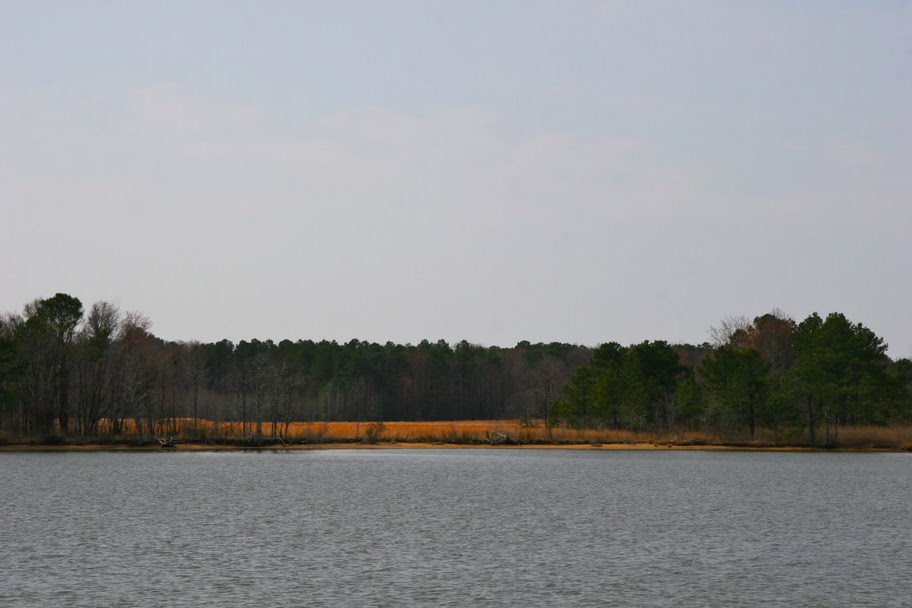
From Herring Bay it's almost a straight shot on course 075 into Eastern Bay, cutting across the north end of Poplar Island. With the light winds we were only making about 5 or 6 knots but it was a beautiful day and we were in no hurry. Once in Eastern Bay we sighted R2A and drove for a spot halfway between it and Long Pt., which is on the south-eastern tip of Kent Island. There's some shallow water that extends off this point and taking this course kept us in deep water, mostly 30'. Once past Long Pt. we lined up R2A and the mouth of Cox Creek and headed north, roughly on course 010.

We're a bare bones operation. We don't have a chart plotter or GPS or radar or any of the high-dollar high-tech instrumentation. At least not yet. For now we have paper charts that are reasonably up to date and a compass that's accurate within about 5 degrees, some really nice binoculars and a depth gauge. On the south side of Warehouse Creek are a few homes and the channel is about 30' out from the end of their docks. As we headed in our depth gauge quickly went from 13' to 6'. We backed down hard and swung to starboard and watched the depth return to 13'. Remember the game "Operation"? It's kinda like that. We took it slow, 3.5 knots all the way in, dodging port and starboard to stay in the deep water.


 Friday was absolutely gorgeous with temperatures in the mid 70's. We had blueberry pancakes and cinnamon coffee for breakfast. Mmm, mmm, good! I spent part of the afternoon chasing ghosts in our electrical system and Cheri kicked back and enjoyed the peace and quiet. I eventually sat down and buried myself in a good book out in the cockpit. It got so warm we had to open up the enclosure to let the breeze blow through and considered shorts and T-shirts for the day. Friday night's dinner was pork chops. We try to eat well to keep from feeling like we're camping. Towards sunset we noticed things poking out of the water all around us. At first we thought they were turtles because they looked kinda rough, almost prehistoric. Cheri broke out the binoculars and found they were fish, about 1' to 2' long, cruising slowly at the surface and what we were seeing was their dorsal fins. I have no idea what kind of fish these were. I'm thinking Jurassic Park.
 Like I said earlier, the wind kicked up Friday evening and neither of us got much sleep. When we first set anchor the wind was out of the SE. It was now blowing out of the N and WNW at 30 knots. I was concerned the anchor would pull loose and we'd wind up on the beach. I kept going up topside to check my bearings and everything was fine. OK, check my bearings? When we first anchored I took sightings with the compass to easily identifiable spots all around us and wrote them down for later reference. If the boat moved more than just swinging on the anchor these readings would change. This is the old fashioned way of doing things because nowadays all you have to do is set the alarm on your phone's GPS and it'll wake you up from a sound sleep. In fact I have this feature on my phone. I just don't use it because just like those fish, I'm a dinosaur. So at 0400 it was really blowing hard and I finally got up, made some coffee and sat up in the cockpit and waited for the sun to come up. If anything happened I could fire up the engine and keep us in deep water. While sitting there I saw gusts over 35 knots but I did notice that the water never got very choppy because this spot is relatively protected.
Saturday morning was windy and chilly, in the 40's. We decided to pack up early and head back home. We pulled anchor which was challenging in a 25 knot blow. It took two tries before I finally got it and it brought with it a huge clump of mud and oyster shells. While I hosed it off Cheri headed out the creek. After we made the turn into Cox Creek it was difficult to tell where the channel was. There was a streak of muddy water coming off Warehouse Creek and it made the water look shallow, like a sandbar. We veered around it and immediately ran hard aground. We backed down hard, full throttle, churned up the mud and clawed our way back to deep water. We then veered back over to the middle of the creek and continued on like it never happened. Running aground is a time-honored tradition on the Chesapeake Bay.


Eastern Bay is big and has lots of potential anchorages for us to try out. The Miles River branches off at the eastern end with many great looking spots, including the town of St. Michaels. There's also Shipping Creek, Crab Alley Bay and Prospect Bay to explore. Considering that this is all within a few hours sail from where we hang out at Herrington Harbour North I'd say we'll be spending a lot of time on Eastern Bay.


No comments:
Post a Comment