Friday, June 12, 2015

Heading South on the Intracoastal Waterway - Part 6


4/30/15 - After settling up our bill with Charleston Harbor Marina (mile 464.5) we prepared to be on our way.  We usually manage our own lines but have always had offers from the host marina for assistance.  We had no offer this time and it didn't occur to me that this might be the one time we really would need it.  The change in tide here can be as much as 6.5' and because of this they use floating docks exclusively.  Backing out of the slip was when I realized how strong the outgoing tide was.  As soon as the stern came around the rushing water caught us and forced us back down towards the dock and other boats. We narrowly missed contact with a power boat but did get pulled sideways into the open slip beside it.  Under full throttle we pulled ourselves back out into the fairway between the docks but managed to drag the port side against the rubber bumper surrounding the finger pier.  We later discovered a 2" wide black racing stripe down most of the length of the boat.  I don't have a lot of experience operating a boat in these ripping currents but I suspect the only way to deal with it is to time your arrival and departure during slack tide.  It would have been helpful if the staff in the marina office had mentioned this.  Driving down the fairway we were starboard side on to the outgoing current and it continued to push us sideways toward the pier.  It was a battle getting out into open water and the sense of relief was strongly felt once we were away from this marina.  All my experience has been on the Chesapeake Bay with 2' tidal changes.  Coming down the ICW we experienced strong tidal flow at anchor but this marina is located on the side of the Cooper River and has no protection from the current.  I may be an old dog but hopefully I'm still learning new tricks.  I won't put us in that kind of situation again.  Woof.


We motored out across the river and rounded Battery Point into the Ashley River.  We saw numerous dolphins along the way.  Entering Wappoo Creek we continued south on the ICW.  At the head of the creek is a short and narrow cut connecting to the Stono River.  The outgoing tide was so strong through here that we could only make 3 knots under full power.  We continued on down several connecting waterways over the rest of the day before finally reaching Fenwick Cut off the Edisto River.  This connected us to the Ashepoo River where we pulled off the ICW and anchored behind Fenwick Island (mile 511.6) in 18' of water.  This area is salt marsh to the south but Fenwick Island is covered with trees providing good protection from any wind from the NW to NE as it was that day.  This is an unpopulated area and the only lights we saw at night were from the channel markers upstream on the ICW.  We felt totally secluded and were caught off guard the next morning to be passed by a large cruise ship, apparently returning from an offshore gambling run.


5/1/15 - We departed our anchorage at 0900 and proceeded into the Ashepoo Coosaw cut which brought us out to the Coosaw River.  Here we had a long upstream run with a headwind of 20 to 25 knots and made slow progress at 4.5 knots.  We finally got to Brickyard Creek which wound it's way down to the town of Beaufort, SC.  Just upstream from the swing bridge is Factory Creek and we turned up the narrow channel here to get to Lady's Island Marina (mile 535.9), which turned out to be so friendly and accommodating that we ended up staying for four nights.

We arrived on a Friday afternoon and decided to make use of the marina's loaner car to replenish our groceries.  The next day we struck out on foot and crossed the bridge into Beaufort.  There was a festival going on in the waterfront park and we spent several hours wandering around the booths and listening to the live music.  We walked into town and checked out some shops then headed down Carteret Street in search of a cigar shop, which we finally found out past the college.  We each got a cigar and an ice-cold beer and enjoyed them while sitting outside under a large sun umbrella.  We continued our walk back through the quiet tree lined streets, eventually finding our way back to the boat in time for dinner.  On Sunday we again borrowed the loaner car and drove out to Hunting Island State Park where we spent the day on the beach.  Just in from the beach the park is covered in forest with an interesting mix of deciduous trees and palms.  There's also a lighthouse here that we viewed from a distance, not feeling up to the challenge of climbing to the top.  We walked up and down the beach for several hours before heading back into town.  Monday we spent doing laundry and cleaning the boat.  It was here that I managed to polish out the racing stripe.  This was a quiet day and we spent the afternoon with drinks in the cockpit.  We also made use of the car one more time and drove out to Lady's Island for some authentic Low Country eatin' at the Gula Grub.


5/5/15 - We departed Lady's Island Marina around 0930, passed through the swing bridge and continued south under power.  We crossed Port Royal Sound and entered Skull Creek behind Hilton Head Island.  This brought us out to Calibogue Sound and the Cooper River.  Our next anchorage was just off the Cooper River on Bull Creek (mile 565.7).  We anchored around the first bend and shared the spot with several other boats.  That evening we worked on our 3D puzzle of St. Basil's Cathedral and took in a pretty spectacular sunset


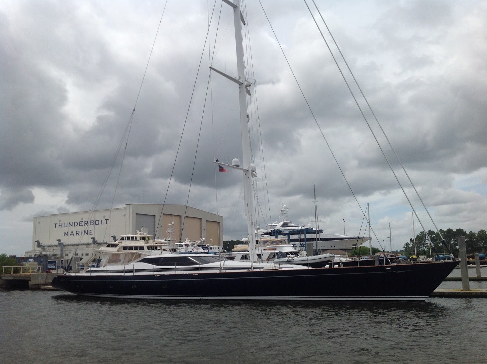

5/6/15 - We continued south through several cuts before crossing the Savannah River and entering into Georgia.  We had originally planned to visit Savannah but everything we read said to avoid it because of the 9' tides and strong currents and would be better visited from the nearby town of Thunderbolt.  Bummer.  I had just finished reading "Midnight in the Garden of Good and Evil" which is a bazaar true story that takes place in Savannah and I was intrigued to see some of the places mentioned.  We'll hafta come back by car for a visit some day.  We passed through the Elba Cut into the Wilmington River and drifted by a cemetery right on the edge of the river.  I instantly recognized it from a picture I had seen and the description as the Bonaventure Cemetery that had played a major role in the "Good and Evil" book.  Cool!  That kinda made up for not going into Savannah.  Just downstream from there we passed the town of Thunderbolt and Thunderbolt Marina.  This place caters to megayachts and we saw a number of them on the hard and tied up at the docks including a sloop that must have been at least 80'.  If you stay at the marina overnight they'll greet you in the morning with a newspaper and Krispy Kreme donuts.  In spite of that temptation we continued to move on.


After passing through four more bridges we came to our next anchorage on Cane Patch Creek (mile 608.4).  This entire area is part of a vast salt marsh and has meandering, intersecting creeks.  I hafta admit that I totally missed our turn for Cane Patch Creek and we had to backtrack about a mile or so. We had been running with the current making about 8.5 knots and I was just enjoying the feeling of driving a formula one car through the twisty turns of the creek.  Or something like that.  Anyway, we anchored way back on Cane Patch Creek between tree covered islands.  The tall green grass of the salt marsh and the trees provided good protection from the wind and rain that came in that night.  The next day we were joined by three other boats and we all waited out an extra day here with reports of  tropical storm Ana forming just off the coast.  On the morning of 5/7 we saw heavy rain with winds as high as 35 knots but remained safe and secure in our anchorage.  During the day the storm worked it's way north up the coast and by the next day we had clear skies again.

Wednesday, June 10, 2015

Heading South on the Intracoastal Waterway - Part 5


4/25/15 - We departed Georgetown (mile 403.0) with our next destination being Charleston, SC which was over 60 miles away.  This would make for a very long day so we chose an anchorage from the guidebook that would work better for us and still get us close.  Heading south on the Waccamaw River into Winyah Bay we entered the Estherville Minim Creek Canal (4.9 miles).  This empties out into a series of landcuts and canals that wind around for the next 45.5 miles through salt marshes.  Driving a boat through the salt marshes is kinda like driving your car through a town with endless intersecting creeks that form a maze forcing you to pay attention to the roadmap, er, charts.  There's also a strong tidal flow and it's associated shoaling through here and that requires paying close attention to the depth gauge.  After 45 miles we felt exhausted and were ready for the next anchorage.  We pulled off the ICW into Dewees Creek and turned into Long Creek (mile 454.3).  We chose this spot because it offers some protection from the strong winds blowing that day.  We anchored in 18' depth with the wind blowing 25 knots and a strong tidal flow in the opposite direction.  Because of the depth, the 6' tide and the strong wind I let out 120' of chain.  Cheri and I use simple hand signals when anchoring for communication and to minimize yelling and confusion.  To ensure that we got the anchor to set properly I gave her the signal for backing down hard in reverse.  When the anchor bit into the sand, mud and shell bottom it was like it had been set in concrete.  We stopped so quickly the bow of the boat dipped down and I was almost thrown over.  Guess we don't have to worry about dragging anchor tonight!  That evening a storm blew in with rain and lightning which lasted through the next day.  We decided to just sit it out for an extra day.

4/27/14 - Our anchorage on Long Creek was just 10 miles out of Charleston (mile 464.5) and from that distance we could see the Ravenel suspension bridge (first picture at top) and the city lights at night.  We departed Long Creek at 1030 and headed south on the ICW, passing under the Isle of Palms bridge (fixed, 65').  The approach to the second bridge, the Ben Sawyer swing bridge, had severe shoaling with depths as shallow as 5'. We touched bottom several times and there was quite a bit of VHF traffic about how best to get through.  When we arrived at the swing bridge we had to wait half an hour for it's next scheduled opening.

We had tried to make reservations at marinas in the city but they were all full so we ended up across the Cooper River at Charleston Harbor Marina.  We found this place to be very expensive with diesel priced a dollar higher ($3.65/gallon) than anywhere else on the ICW and slip rates at $2.15/ft.  The location also suffered from a strong tidal flow that made entering and departing the slip very difficult.  Grrr.  They did offer a water taxi service ($6.00 in each direction) but redeemed themselves with a free shuttle that only took 15 minutes to get into Market Street in Charleston.  We made good use of the shuttle.

Once we got settled in at the marina we headed over to Charleston and spent the afternoon touring the city.  We started at the Slave Museum where we picked up a book for a self guided tour of the city.  We spent the rest of the day wandering the streets of the old part of town, learning the history and enjoying the beauty.  Had lunch at the Brown Dog Cafe.  On 4/28 we returned for another day of wandering.  Charleston is known for fine dining and has a long list of excellent restaurants.  We stumbled on 82 Queen for lunch and enjoyed our meal while seated outside in the courtyard.  We had no real plans for this day, mostly intentions to shop.  We didn't get far though before we discovered a nice little cigar shop that also offered beer and wine.  We commandeered a table just inside the entrance and stayed there for five hours.  We spent the rest of the day making new friends with the shop owner and several of the locals.  One in particular was an older gal who turned out to be a professional walking-tour guide in the city.  She loved to talk and if you had listened in on the conversation you would have thought we had all known each other for years.  Another character we met was an author who was working on a book about serial murderers in the US.  This was the highlight of our visit to Charleston.  Fine wine, great cigars and friendly and interesting people.  Who could ask for more?

Our last day there was a rainy one so we spent it at the marina doing laundry and cleaning up the living quarters on the boat.  Next to the marina was a Naval Museum with an aircraft carrier (USS Yorktown) and destroyer (USS Laffey).  We wandered over and took a look but didn't want to invest in the $40 (for two) entry fee.


This is a beautiful city with history going back to it's 1670 origins.  In 1718 the city was besieged by Blackbeard the pirate and in it's early years was under constant attack by the French, Spanish and Native Americans.  During the Revolutionary War the city was attacked by the British fleet several times.  The first time they were repelled by a hastily built fort made of Palmetto logs.  The "liberty" flag flown in this battle became the state flag for South Carolina with the addition of a Palmetto tree emblem commemorating this battle.  The second attack in 1780 was more successful and the British held the city for two years.  This was considered the greatest American defeat of the war.

Charleston played a leading role in the slave trade with something like 40% of all slaves in America brought over from Africa.  When international slave trade was outlawed in 1808 Charleston became the center of an even larger domestic slave market with slaves being brought there for sale from all over the south.  The slave museum we visited had been a huge indoor slave market in the mid-1800's.  We learned that our home state of Maryland was a major contributor.  During this time Charleston also became a big exporter of Indigo, a blue dye that was in short supply in Europe.  It's also what's used to make bluejeans blue.  In 1862 the attack on Fort Sumter in Charleston's harbor began the Civil War.  During the war a blockade was established that effectively ended commercial traffic in the city.  It was at this time that one of the first submarines, the H.L. Hunley, was used in naval warfare, attacking one of the ships in the blockade.  In 1861 Charleston was ravaged by fire, unrelated to the war, which burned over 500 acres of the city.  In 1886 the city was nearly destroyed by one of the strongest earthquakes to hit the East Coast, registering 7.3 on the Richter scale, second only to the New Madrid earthquakes of 1811 and 1812.  The city's economy languished for decades but has recovered to become well known world-wide for it's art, music, local cuisine and fashion.  We found Charleston to be a beautiful city with an interesting history and plenty of interesting people.  This was  easily the best part of our trip down the ICW.

Monday, June 8, 2015

Heading South on the Intracoastal Waterway - Part 4


4/21/15 - We departed the Carolina Beach anchorage at 0900 and entered Snow's Cut which brought us out to the Cape Fear River.  Nothing to fear here.  We crossed the river and headed downstream.  About half way down we had to wait while two tugs brought out a tanker and turned it to begin it's journey out to the ocean.  As the tanker got under way the narrow river got crowded with the departure of the tugs and the arrival of a Coast Guard cutter.  We held our ground (so to speak) and waited for things to clear out before proceeding onto Southport where we continued south on the ICW.  This day we passed through or under six bridges, a signature of traveling on the ICW.  We came through a small fishing village where shrimp boats were tied up and saw the remains of what appeared to be hurricane damage from last season.  We crossed into South Carolina (mile 340.9) where a large cruise ship entered behind us from the ocean, apparently returning from a gambling cruise off shore.  We had hoped to anchor for the night at the Calabash River but found it already crowded when we arrived so we continued on with the cruise ship slowly gaining on us.  We called ahead to a marina and made arrangements to stay there.  As we approached the marina the cruise ship turned off behind us and docked, ending our worries about providing room enough for him to pass.  We had tried contacting him several times on VHF to allow him to pass us but he never responded, apparently knowing his stop was coming up soon.  We tied up at the fuel dock  at Cricket Cove Marina (mile 345.1) which is right on the ICW.  This is a nice marina with complete service facilities and a decent restaurant where we ended up for dinner, each having Grouper.  Mmmmm, mmm, good!


4/22/15 - We headed out around 0900 (apparently the best we can do) and entered Pine Island Cut, a 28 mile land cut.  When this was built in the 1930's by the Army Corp of Engineers they encountered a stretch of hard rock 2.4 miles in length which took them two years to blast through.  Because of the difficulty they had this stretch is much narrower than the rest of the muddy bottomed cut and has become known as "The Rock Pile".  It's only wide enough for one boat at a time and you're supposed to announce your intentions on the VHF before entering.  Since we were running early in the cruisers season we didn't encounter a lot of traffic through this part.  This is the Myrtle Beach area and we passed through and under a total of twelve bridges this day.  Once through the cut we entered a beautiful cyprus swamp where we saw numerous Bald Eagles and their nests.  We anchored on Bull Creek (mile 381.0) in 15' depth, way back off the ICW and about 50 yards from an Eagle's nest.  This was one of the nicest anchorages we had on the entire trip with total seclusion from any sign of man, completely surrounded by the beauty of nature.  At night the only light was from the stars above and once my eyes adjusted to it I found that was enough to make out the trees on the shoreline.

 4/23/15 -


We had been in touch with friends Pete and Sharon (m/v Emerald Lady) who were heading north on the ICW after spending the winter in the Bahamas.  The plan was to meet up with them in Georgetown, just 21 miles to the south of us.  If it wasn't for that we would have stayed longer at Bull Creek.  We got underway at 0930 and meandered through the cyprus swamp before passing under Lafayette Bridge and entering Georgetown Harbor in the early afternoon.  We had reservations at Harborwalk Marina, just walking distance from the historic downtown part of the city.  Pete and Sharon met us on the dock and we got together on their boat for drinks before heading into town for dinner.  We ended up at "700" on the advice of a local and weren't disappointed.  The food was excellent and we had a good time catching up with old friends.


Emerald Lady departed the next day but we stayed on to take in the sights.  We walked down Front Street and checked out all the shops before heading over to get groceries at the Piggly Wiggly, a mile and a half away.  We walked back through the old residential part of town in the shade of the old oak trees lining the streets.  Georgetown has a lot of history going back to 1526 when the Spanish attempted a colony here.  In the Revolutionary War two signers of the Declaration of Independence came from Georgetown as did the Swamp Fox, Francis Marion, originator of guerrilla warfare.  By 1840 Georgetown was the largest rice-exporting port in the world and there was considerable wealth in the area with many of the fine homes remaining to this day.  Throughout the next hundred years Georgetown hosted the largest lumber mill on the East Coast and the largest paper mill in the world.  The town suffered major damage in 1989 from Hurricane Hugo but on our walk through the neighborhoods it appeared to be completely restored.  Visiting Georgetown was one of the highlights of our trip down the ICW.

Wednesday, June 3, 2015

Heading South on the Intracoastal Waterway - Part 3


4/17/15 - After several enjoyable days at River Dunes Marina (mile 173.9) we decided it was time to move on.  We had a long day ahead of us so we opted for an early start (early for us) and were on our way by 0830.  We were headed out to the coastline and would be passing through five bridges.  We motored out Broad Creek and brought out the main and Genoa for a nice sail across the Neuse River into Adams Creek where we motor sailed up to the canal connecting to Core Creek.  I spotted my first dolphin in Core Creek but the crew wouldn't believe it since we still seemed to be so far inland.


Core Creek empties into Newport Marsh and this brought us to Morehead City and the town of Beaufort.  These two towns face each other across the ICW and have distinctly different personalities.  Both are popular stopping off points for cruisers but power boats tend to go to Morehead City and sailors seem to favor Beaufort.  We favored neither and passed them both.  Once we got past the highway and railroad bridges connecting the two towns we continued on for a while before realizing we had missed our turn and were headed out to the Atlantic Ocean.  Oops!  The chart at left shows our track as we turned around and headed back to Morehead City.  This part of the coast has barrier islands and the ICW runs behind them staying well protected from the ocean.  It's still influenced by the ocean tides though and the current is constantly an issue here, either with you or against you.  Running with it we made as much as 8.5 knots but against it we slowed to sometimes less than 4.  Because of this and the nice sea breeze we brought out the sails again and motor sailed to keep our speed up above 6 knots the entire way. Being able to sail through here kept the day interesting because the view doesn't change all that much throughout this region.  As wide as this waterway is through here it's mostly shallow water and the ICW has sand bars on either side of it.  At low tide the water drops 4' to 5' and I quickly learned to drive with the depth gauge as my primary instrument.  I found I could slowly work my way over to the side until I saw the depth go from 8' to 7' to 6'.  We draw 5' so I'd then veer back towards the deeper water to stay in the channel.  This method made it easy to pass oncoming boats as this was a busier part of the ICW.  Up until today we had for the most part been the only boat on the water.  We marked our progress by the bridges that connected the mainland to the beaches.  This was also where we saw our first problems with shoaling where the rushing tidewaters filled the channel with sand in many places.


Around 1630 we tried anchoring between two large dunes in about 9' of water.  Seemed like a perfect location with dolphins all around and a nice view of the barrier island but as the tide changed we found ourselves in the middle of a ripping current.  We quickly pulled up the anchor and moved on.  Several miles further on we came to the town of Swansboro (mile 228.0) where we anchored just off the town dock with two other boats.  The pictures at left show our first anchorage between the dunes and our second choice in the creek off Swansboro.  This was a nice location and the tidal changes kept us swinging in tight circles all night.  I woke up at 0300, shortly after the tide had changed, and went up on deck to check things out.  While I sat there for 20 minutes I watched the current pick up and slowly bring the boat through a 180 degree turn.  The only real drawback about Swansboro was the bar at the end of the bridge that had a live band cranking out tunes until early morning hours.  It's fine when you're in there with a cold beer in your hand and your lovely wife on the bar stool beside you but not when you're at anchor trying to get some sleep.  Party on Garth.


4/18/15 - We departed Swansboro anchorage and continued south under power  with overcast skies and light rain.  We have a full enclosure on our cockpit which keeps us out of the wind and rain but the Eisenglass windows at the front don't have windshield wipers and it makes it difficult to see where you're going.  Every now and then I'd ask Cheri to wipe them down.  We kept this day's run short and stopped at Mile Hammock Bay (mile 244.4), a large basin at Camp Lejeune Marine Corp base.  When we arrived there was just one other boat at anchor but towards 1700 it quickly filled with northbound cruisers.  The next morning it just as quickly cleared out but because of the continuing rain we decided to stay another day.  We spent our time working on our 3D puzzle of St. Basils Cathedral, playing Carcasonne ( a great game we had picked up for this voyage) and relaxing with Bloody Marys and cigars.  Also took the time to service the genset, changed the oil and filter.  It was nice to just sit back and do pretty much nothing for a day.


4/20/15 - We woke up to a beautiful, clear day.  Got underway late, around 1100, because our next anchorage was only 39 miles away and we figured we could be there by 1700.  This next stretch of the ICW was through a more populated area with McMansions built along the edge of the waterway.  Since this area is a beach resort we also saw some interesting vacation homes with lotsa pinks and blues and turquoises.  We also experienced 6' tidal changes and some serious shoaling.  In some parts the channel was shifted over considerably to one side with only room for one boat to get through at a time.  Temporary channel markers were in place to help show the way.  When we arrived at our anchorage (Motts Channel, mile 283.4, chart at left) we found it to be in the middle of a village.  Restaurants were built right along the ICW and we felt like we were on display as we cruised through.  Of course it was in front of all these observers that I missed my turn for the anchorage.  I doubled back and eased into the cut that would take us back behind the barrier island.  The guide book and the charts all showed this entire area to have 15' depths so I proceeded without fear.  We immediately ran hard aground in the middle of the channel.  Everyone watched as we tried to get free.  A tow service came out thinking they had some easy money but it was just then that we broke free and backed our way out to the ICW.  OK, plan B.  The next anchorage was another 12 miles further south, at least two more hours, which would get us there after dark.  We pushed on regardless.  As the sun got lower in the sky the wind began to pick up and by the time we got to Carolina Beach it was blowing 20 knots.  Carolina Beach (mile 295.1) has several anchorages in deep water (30') right in the center of town.  We chose an area between two islands and a mooring field.  The tide was running strong and the wind was blowing in the opposite direction.  The boat wanted to lay at 90 degrees to both and we had a hard time setting the anchor.  Because I felt uncomfortable with it I went up on deck throughout the night and tried to verify our location using the lights from buildings on shore.  Seemed OK.  When we got up in the morning we found the anchor had dragged about 100 yards.  Yikes!  Luckily there were no other boats around and we were still in deep water.  We also found a duck sleeping on the bowsprit, apparently exhausted from standing the anchor watch all night.

So this had been an "Oops" day.  Better charts might have made a difference at Motts Channel but with all the shoaling we saw along the way I doubt we would have had any better luck.  Our anchoring at Carolina Beach was another matter, something to learn from.  We have a new anchor, a Rocna 33, that has a world-wide reputation for holding under any condition.  I had become comfortable with this notion and paid the price here.  From this point on we made absolutely sure the anchor was set by backing down hard in any condition until we really felt the anchor bite in.  In fact at one anchorage in a South Carolina salt marsh it bit in so well the boat came to a screeching halt as though we had slammed on the brakes in a car.  Almost threw me overboard.  Didn't have to worry about dragging the anchor that night!

Monday, June 1, 2015

Heading South on the Intracoastal Waterway (ICW) - Part 2


4/13/15 - The pictures to the left show the sunrise from this morning and the totally unpopulated shoreline where we anchored.  We departed Southshore Landing (mile 81.9) anchorage on the Little Alligator River and continued South under power.  The channel taking us back out to the Alligator River is about 7' deep, narrow and surrounded by knee deep water.  It winds around for about 4 miles, doubling back on itself so you pass within a hundred feet of where you were twenty minutes ago.  By this time I had realized that my electronic charts were really meant for bigger water and the coverage on the ICW was often offset to one side (sometimes showing us on dry land!) and depth information was mostly non-existant.  I had gotten pretty good at glancing at the chart, reading the surface of the water and paying close attention to the depth gauge.  It's a wonder that by the end of this trip we had only run aground three times.


Once we got back out to the big river we passed through the Alligator River swing bridge.  This was the first bridge we encountered that didn't have any kind of schedule for opening.  The two bridges on the Dismal Swamp Canal had a relaxed schedule but they were on small roads and were a simple operation.  This was on a major road, maybe the only road in the area, and it's a large bridge.  We hailed the bridge tender and he let us know that by the time we got close enough he'd have it open for us.  They man this bridge 24/7 and open on demand.  This was a real indication of how far out in the sticks we were.  As it turned out, many of the bridges for the rest of our trip were either a fixed span (65') or opened on a schedule every hour or half hour except during morning and evening rush hours.


At the southernmost end of the river we entered the Alligator River / Pungo River Canal.  This is a 21 mile long cut between the two rivers and it's wide, deep and straight as an arrow.  About the first 2/3 of it is all Cyprus swamp.  We saw only two other boats the whole time we were on the canal.  Around 1530 we came to the Pungo River.  I had chosen an anchorage that was just off to the right but when we turned into it we found it poorly protected from the strong SE wind that was blowing across the river.  We decided instead to try another anchorage a little further south on Scranton Creek (mile 129.5).  This was indeed just a creek with a narrow channel that wound it's way back into a salt marsh (?) with tall trees on the higher ground providing good protection.  At first we were a little concerned because there was just enough room to make a tight turn in the creek but the depth was 15' with good holding for the anchor.  We settled in for the night with the wind howling above the mast but having no effect on us down at the surface.  Beautiful anchorage.

4/14/15 - It's now been nine days since we started on our trip.  It was time to restock on groceries, top off the fuel tank and pump out our holding tank.  It was time for a visit to a marina.  Our guide book mentioned several in the area and we opted for one right across the river from Scranton Creek, Dowry Creek Marina.  It took us about 45 minuted to get there and get tied up.  It looked like a nice place but we quickly found out it was owned by a couple and they'd apparently grown tired of it and were anxious to sell.  There was no pump-out service available although it was advertised.  They claimed they were concerned about their lines freezing and wouldn't get it operational until May 1st.  What?  Our marina back in Maryland had their systems up and running by the end of March.  I suspect the owner was just too lazy to get it running until he had a little more business to make it worth his while.  They also advertised a loaner car to use for running into town, just a few miles down the road.  The car was a beat up Dodge Durango with power windows that wouldn't roll down, no A/C, no fan and it was only running on five cylinders.  We had to drive into town with the passenger door held open to get some fresh air.  It was a joke but it got us where we needed to go and we restocked our groceries.  When we got back to the marina early that afternoon I had a question for the owners but they were not to be found.  This is a very laid back operation, a little too laid back for us.  When we finally found the owners we settled up our bill and planned to leave early the next day.


4/15/15 - We left early and motor sailed down the Pungo River with 15 knot winds out of the NW.  We crossed the Pamlico River into Goose creek where we furled the sails and entered another canal which brought us out onto Bay River.  Here we found the wind had picked up to 20 knots NE and it continued to build as we entered Pamlico Sound and the Neuse river.  Seas were pretty rough with short period waves at about 4' but the wind was blowing with us after we turned into the Neuse.  We ran down a short way and turned into Broad Creek.  Here we found good protection from the wind and we meandered our way back to River Dunes Marina.  This place is pretty amazing.  The entire peninsula had previously been owned by Weyerhaeuser Corporation where they harvested the trees.  The new owners dug out a 23 acre, 15' deep marina and opened it out to Broad Creek.  They also began building a town and selling lots for high-end homes, all built with a late 1800's theme.  The marina is top-drawer but their rates are competitive with everyone else, even Dowry Creek.  We stayed two nights and spent time riding bicycles around looking at the homes and dreaming up ways to buy some land.  We used the loaner car, a brand new van with everything working properly, and drove about 8 miles into the nearest town, Oriental.  This town is a major stop-off for cruisers on the ICW and has many nice shops and good places to eat.  We enjoyed a great dinner at the Toucan Grill down on Raccoon Creek.  We had a great time at River Dunes and Oriental.  The top two pictures here show one of the cool-man homes and the marina.  The building with the red roof is the marina office.  How cool is that?